
Lake Effect Weather: What Causes It?
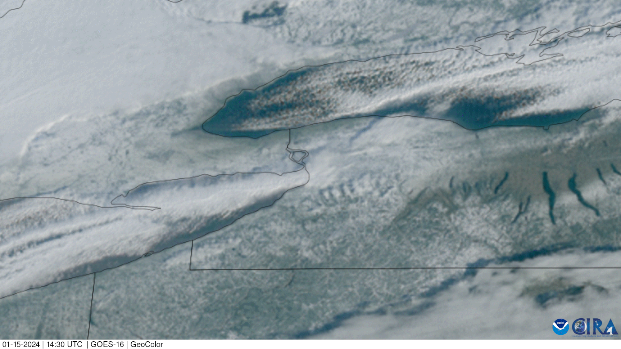
GOES-16 satellite image shows lake effect snow bands over Lakes Erie and Ontario.
Image from NOAA
Bill - The Wx Learner - October 24, 2025
Fall is upon us, so it’s time to take a look at lake effect weather. These weather events occur downwind of the Great Lakes. The simple explanation is that cold air moves across a warm lake. I’ve been doing research on it all week, and I’m getting a better understanding of it. This is just a basic description of how it forms. I just wanted to give everyone some understanding to what causes all the crazy weather in the Great Lakes region in the fall and winter.
How Lake Effect Weather Forms
It starts when cold, dry air comes in from Canada or the upper Midwest and moves across the warm waters of the lake. At first, the air doesn’t carry much moisture, but that all changes as it moves over the lake. Most strong events occur after a cold front has passed and a large, cold air mass sits over the region.
As the cold air travels across the warmer lake, it picks up heat and water vapor. The air near the lake becomes warmer and more humid than the air above it. This creates instability and rising motion. Once the rising air cools enough to reach the saturation level, clouds and precipitation begin to form. The type of precipitation depends on the surface temperature.
If the air at the 850 mb level (about 5,000 feet up) is at least 13° C (23° F) colder than the lake’s surface temperature, it is favorable for lake effect weather. The greater the temperature difference, the greater the amount of energy and moisture the lake can produce, intensifying the storm.
That instability is just the start. The larger weather pattern determines whether this setup will really get going.
These lake driven events are enhanced by cyclonic flow. This means there is low pressure and a counterclockwise flow of air. This pulls cold air down from the north and across the Great Lakes. The distance that the air travels across the lake is called the fetch. When the fetch is longer, the air picks up more heat and moisture causing the intensity of the precipitation to increase.
Cyclonic flow often brings positive vorticity advection, which promotes ascent and enhances lake effect weather. Vertical motion along and behind the trough strengthens the process.
That’s not to say anticyclonic flow (clockwise motion) can’t bring lake effect weather. Anticyclonic rotation causes sinking air and a stable atmosphere. But, as long as there is cold air moving across the warm lake, the temperature contrast creates lift, fueling narrow bands.
Wind Drives It
Once the lake effect gets going, the wind determines where the bands form and where they will hit.
These storms are very localized. The lake behaves like its own system. You could have whiteout conditions at your house and travel down the road and have it be clear.
Let’s use Lake Erie as an example. When the winds shift to a southwest direction, the bands have a long fetch across the lake. This produces intense, long-lasting snow in Buffalo. When we have west winds there is a long fetch as well, creating the most intense weather in Erie County. When the winds turn northwest out of Canada, the fetch shortens and the bands intensify as they move inland due to the air being forced over the higher elevations. This lift causes the air to cool even more, causing the most intense weather in southern Erie County and Crawford County. This is why a lot of times you see the highest accumulations in these areas.
A small shift in the wind can completely change the trajectory of the storm, which can cause the forecast to change by the minute. This makes a forecaster’s job hard, especially in the winter.
The Seasonal Changes
We start to see lake enhanced precipitation in October as the air in the atmosphere cools while the lakes remain warm. This starts as rain. Once the surface temperature is below freezing it becomes snow. Early in the season, when the surface temperature is still warm, the precipitation starts as rain and transitions to snow inland as the surface temperature falls below freezing. As the temperature of the lake cools, the 850mb temperature must be even colder to support a lake effect event. Remember, there must be at least a 23° F temperature difference between the air and lake. If the lake freezes, there is nothing to fuel the cold air coming across the lake. Lake effect snow is done for the season.
Final Words
Having lived in Erie my whole life, lake effect weather is one of the things that made me become so obsessed with the weather. It is one of the most fascinating things in meteorology to me. The way the lake can have such a strong influence just shows how powerful it is.
As another season of lake effect begins, I’m excited to implement what I have learned into forecasting and continuing to share what I learn along the way.
Want to know more about the weather? Check out my post on what influences the weather.