
Atmospheric Rivers: What They Actually Are
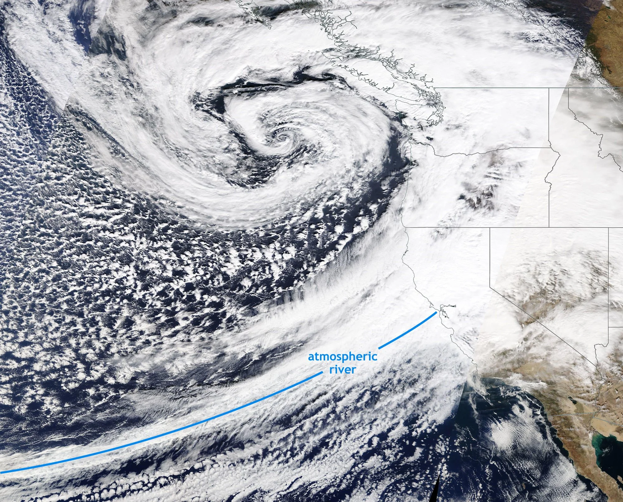
Satellite Image from October 24, 2021 when an intense Atmospheric River hit SanFrancisco. Image from NOAA
Bill - The Wx Learner - December 5, 2025
Atmospheric Rivers have been in the news recently, especially with the massive rainfall in California. They have driven flooding, landslides, and record breaking precipitation. So for this post, I decided to take a look at what Atmospheric Rivers are and why they matter.
What are Atmospheric Rivers?
Simply put, an atmospheric river is a long, concentrated corridor of tropical moisture that gets pulled into the United States by the jet stream. When that moisture meets mountains or slows down in the atmosphere, the air rises and drops heavy rain or snow.
Think of it like a conveyor belt.
Warm, humid air from the tropics gets picked up and transported thousands of miles away from where it started. The Pacific Northwest and California get the most attention, but these rivers can reach Alaska, British Columbia, and sometimes even continue across the entire United States. Some of the West Coast’s biggest winter storms on record were powered by atmospheric rivers.
How They Form
What is really interesting is how they form.
Most atmospheric rivers grow out of the warm pool of tropical moisture near Hawaii, the western Pacific, or the subtropics. They develop when a strong jet stream taps into that moisture and pulls it northeast. The jet doesn’t just steer them, it actually strengthens them by speeding up the transport of water vapor. Faster winds mean a stronger moisture pipeline.
They are not all the same. Some bring steady rain and help build snowpack. Others fall into the “AR scale,” which ranks events from AR1 (weak) to AR5 (exceptional) based on both moisture content and duration. AR5s are the ones that lead to major flooding, landslides, feet of mountain snow, and rapid rises in rivers. The moisture content in a strong atmospheric river can exceed the flow of the Mississippi River.
Why The West Coast Gets Hit
The terrain of the West Coast is what turns these into high impact storms.
When an atmospheric river slams into mountains like the Coastal Range or Sierra Nevada, the air rises quickly, due to orographic lifting discussed in my previous post. Rising air cools, moisture condenses, creating the perfect recipe for a strong event. It could lead to inches of rain and feet of snow.
Benefits of Atmospheric Rivers
Atmospheric rivers aren’t all bad, though. They’re responsible for a huge amount of the West Coast’s water supply and snowpack. The snow from these storms feeds reservoirs long after the event is over. California relies heavily on them. But the balance is delicate: too few, and the region slips toward drought. Too many, and flooding becomes unavoidable.
What Shapes Them
Two of the main influences on atmospheric rivers are the MJO and climate change.
The Madden-Julian Oscillation (MJO) is a tropical pattern that can boost or suppress moisture supply across the Pacific. When the MJO is in the right phase, the Pacific moisture pool becomes deeper and richer, giving atmospheric rivers more fuel. When the MJO is quiet, atmospheric rivers still happen, but they tend to be weaker or shorter-lived.
Climate change also shapes these events. Warmer air holds more moisture, which means atmospheric rivers are becoming even wetter. They’re not necessarily happening more often everywhere, but the stronger events, the AR4s and AR5s, are bedoming stronger. More moisture and efficient orographic lift increase the odds of major flooding and massive snow totals.
The Bottom Line
The bottom line is atmospheric rivers are moisture pipelines. On their own, they don’t guarantee heavy rain or snow. But when the jet stream aims them at the coast and the air is forced to rise, you get a high-impact storm. They’re one of the biggest players in West Coast weather, and as long as the Pacific keeps supplying deep tropical humidity, they’ll stay at the center of winter’s biggest headlines.